


ผลิตภัณฑ์ทั้งหมด
-
เครื่องวัดสเปกโตรมิเตอร์แบบพกพา
-
เครื่องวัดค่าสเปกโตรมิเตอร์ที่มีสี
-
เครื่องวัดสเปกโตรโฟโตมิเตอร์
-
เครื่องวัดความยาวคลื่นแบบพกพา
-
เครื่องวัดความหมอก
-
กล้องถ่ายภาพ Hyperspectral
-
เครื่องวัดสีห้องปฏิบัติการ
-
เครื่องวัดความเงาแบบพกพา
-
มิเตอร์วัดแสงดิจิตอล
-
เครื่องวัดความเงาแบบหลายมุม
-
กล่องไฟสี การจับคู่ เบา
-
ซอฟท์แวร์การจับคู่สี
-
เครื่องวัดสเปกโตรโฟโตมิเตอร์
-
ชุดทดสอบสี Pantone
-
เครื่องวัดการส่งผ่านแสง
-
 Yulita Jocomขอบคุณมากสำหรับการสนับสนุนของคุณเกี่ยวกับคุณภาพของผลิตภัณฑ์และให้ราคาที่แข่งขันได้เพื่อช่วยให้เราขยายการตลาดท้องถิ่นของเราในช่วง 2 ปีที่ผ่านมา
 -
Johanna Brathwaiteเครื่องวัดค่าสเปคโตรมิเตอร์ช่วยให้เราสามารถช่วยควบคุมคุณภาพของสีพลาสติกได้เป็นอย่างดี
-
มูฮัมหมัด Imranเครื่องมือและซอฟต์แวร์ทำงานได้ดีเยี่ยม ขอบคุณมากสำหรับการบริการลูกค้าที่ยอดเยี่ยมของคุณ
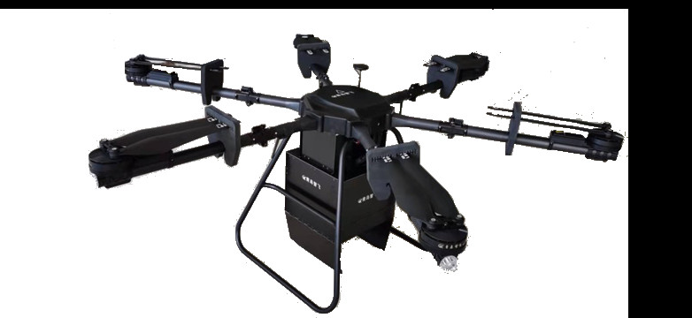
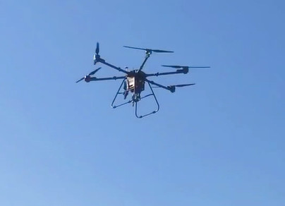
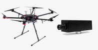
FS60- UAV Hyperspectral Imaging Camera for High-Stability Spectral Image Acquisition


ติดต่อฉันสำหรับตัวอย่างฟรีและคูปอง
whatsapp:0086 18588475571
วีแชท: 0086 18588475571
Skype: sales10@aixton.com
หากคุณมีข้อกังวลใด ๆ เราให้ความช่วยเหลือออนไลน์ตลอด 24 ชั่วโมง
xรายละเอียดสินค้า
| ความแม่นยำของตำแหน่ง RTK | RTK FIX: 1 ซม.+1 ppm (แนวนอน) 1.5 ซม.+1 ppm (แนวตั้ง) | ความถี่ในการทำงาน | 2.4000-2.4835 GHz 5.725-5.850 GHz |
|---|---|---|---|
| ความเร็วในการถ่ายภาพ | เต็มแบนด์ 128Hz, 3300Hz สามารถทำได้หลังจาก ROI | SNR (สูงสุด) | 600/1 |
| ระดับการป้องกัน IP | IP45 | ระบบแสง | แสงแบบพาสซีฟ (ไม่มีแหล่งกำเนิดแสง) |
| เวลาบินสูงสุด | 55 นาที | ช่วงสเปกตรัม | 400-1000นาโนเมตร |
| วิธีทางสเปกโทรสโกปี | ตะแกรง | ความเร็วการบินสูงสุดในแนวราบ | โหมด S: 23 ม./วินาที, โหมด P: 17 ม./วินาที |
รายละเอียดสินค้า
FS60- UAV hyperspectral measurement system
The FS60 unmanned Superspectral Survey system used a high signal-to-noise ratio and a high-speed CCD imaging device to ensure highly stable spectral imaging. The independently developed low-efficiency image processing calculation method greatly increased the flight time of finished products and lowered the system's energy consumption.
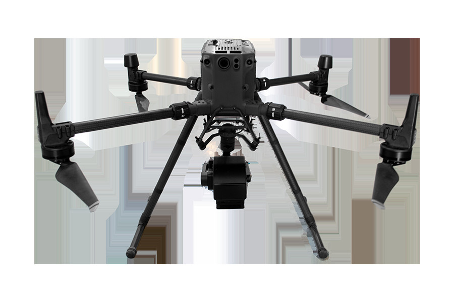
♦Dji M300RTK (DJI M600Pro optional) is used as the flight bearing platform.
♦Ultra-high speed spectral scanning imaging device with high signal-to-noise ratio provides high stability of
spectral image acquisition.
♦A self-developed high efficiency and low power image processing algorithm is adopted to greatly prolong the
flight time of the whole machine and reduce the power consumption of the system.
♦Through real-time measurement of spectral image information of plants, water, soil and other ground objects, it
can be applied to precision agriculture, crop growth and yield assessment, forest disease and insect pest
monitoring and fire monitoring, coastline and marine environmental monitoring, lake and watershed environ
mental monitoring and other applications.
♦The system design is compact and the main spectral resolution of the imaging spectrometer is up to 2.5nm.
Components: high stability head, hyperspectral imager, embedded data acquisition and processing storage
unit, wireless image transmission system, GPS-RTK navigation system, ground receiving workstation, ground
control system, reflectance calibration board.
Applications
Technical parameters
Flight unit parameters (M300RTK)
| Size | Dimensions (expanded, excluding blades) : 810 x 670 x 430 mm (L x W x H) |
| Dimensions (folded, including blades) : 430 x 420 x 430 mm (L x W x H) | |
| Symmetrical motor wheelbase | 895 mm |
| Weight (including lower | Air weight (without battery) : 3.6kg |
| single head bracket) | Air weight (including dual batteries) : 6.3kg |
| Maximum load of single gimbal damping ball | 930g |
| Maximum takeoff weight | 9 kg |
| Working frequency | 2.4000-2.4835 GHz 5.725-5.850 GHz |
| Transmit power (EIRP) | 2.4000-2.4835 GHz: |
| 29.5 dBm(FCC);18.5dBm(CE)18.5 dBm(SRRC);18.5dBm(MIC) | |
| 5.725-5.850 GHz:28.5 dBm(FCC);12.5dBm(CE)28.5 dBm(SRRC) | |
| Hover accuracy (P-GPS) | Vertical: ± 0.1m (when visual positioning works normally) ± 0.5m (when GPS works normally) |
| ± 0.1m (when RTK positioning works normally) | |
| Level: ± 0.3m (when visual positioning works normally) ± 1.5m (when GPS works normally) | |
| ± 0.1m (when RTK positioning works normally) | |
| RTK position accuracy | RTK FIX: 1 cm+1 ppm (horizontal) 1.5 cm+1 ppm (vertical) |
| Maximum angular velocity of rotation | Pitch axis: 300°/s Heading axis: 100°/s |
| Maximum pitch angle | 30° (P mode with forward-vision system enabled: 25°) |
| Maximum rate of rise | S mode: 6 m/s,P mode: 5 m/s |
| Maximum velocity of descent (vertical) | S mode: 5 m/s,P mode: 4 m/s |
| Maximum sloping descent rate | S mode: 7 m/s |
| Maximum horizontal flight speed | S mode: 23 m/s,P mode: 17 m/s |
| Maximum flight altitude | 5000 m (2110 blade, takeoff weight ≤7 kg) / 7000 m (2195 plateau quiet blade, takeoff weight ≤7 kg) |
| Maximum wind speed tolerance | 15m/s (12m/s during takeoff and landing) |
| Maximum flight time | 55 min |
| Supports the gimbal installation mode | Single holder set at the bottom, single holder set at the top, double holder set at the bottom, single holder set |
| at the bottom + single holder set at the top, double holder set at the bottom + single holder set at the top | |
| IP protection level | IP45 |
| GNSS | GPS+GLONASS+BeiDou+Galileo |
| Operating ambient temperature | -20°C to 50°C |
Hyperspectral camera parameters
| Lighting system | Passive lighting (without light source) |
| Spectroscopic methods | Grating |
| Spectral range | 400-1000nm |
| Spectral band | 1200 |
| Resolution of spectrum | 2.5nm |
| Slit width | 25um |
| Transmission efficiency | >60% |
| Stray light | <0.5% |
| Number of spatial pixels | Maximum 1920 (software configurable) |
| Pixel size | 5.86um |
| Imaging speed | Full band 128Hz, 3300Hz can be achieved after ROI |
| Detector | CMOS |
| SNR(Peak) | 600/1 |
| The camera output | USB3.0 or Gigabit network |
| The camera interface | C-Mount |
| Accessories | USB3.0 transmission line or Gigabit network transmission line |
| ROI | Multiple regions |
| Embedded data acquisition and processing storage unit | I7 processor 512GSSD storage |
![]()
♦Easy to operate, it can achieve single operation without professional
drone operator.
♦The ground station can be used to observe the sampling location of the
aircraft in real time, and the ground station can be used to set the
preview and correction functions of the route data collected
point-by-point: radiosity correction, reflectance correction and regional
correction support batch processing.
♦Real-time common vegetation index calculation function.
♦Support custom real-time analysis model input function.
♦ENVI is perfectly compatible with multiple data formats.
แนะนำผลิตภัณฑ์